


Ship API
Column Name | Description | Example |
shipId | SeaVantage unique vessel ID | d3f429de-15b9-4521-824e-11d185771c8a |
imoNo | Vessel IMO registration number | 9790139 |
mmsi | Maritime Mobile Service Identity: vessel unique identification number | 636017754 |
callSign | Call Signs | D5MO4 |
shipName | Vessel Name | OCEAN BLUE WHALE |
shipAliasName | Ship Aliases | null |
shipType | Vessel Type | ETC |
shipTypeBySize | Vessel Type/Size | ETC01 |
shipTypeCargo | Types of ship cargo | Passenger Vessel (unspecified) |
shipImage | Ship image | null |
built | Year of Manufacture/Built | 2017 |
dwt | Total weight of goods | 11553 |
hullType | Type of Ship/Model | Single |
gt | Gross Tonnage | 19480 |
destination | Destination | null |
eta | Estimated Time of Arrival (ETA) | null |
shipStatusType | Vessel Status Code | Active |
builtBy | Shipbuilding Company | Huanghai Shipbuilding Company Limited |
builtAt | Shipbuilding Location | China |
loa | Overall Length | 182.72 |
depth | Overall Depth | 12.1 |
maxDraught | Maximum Draft | 7.2 |
engineBuiltBy | Maximum Draft | Doosan Engine Company Limited |
designedBy | Engine Designer | MAN Diesel AS |
serviceSpeed | Operating Speed | null |
nationCode | Nationality/Flag State | LR |
useYn | Usage Status / Availability | Y |
position | ||
deviceType | AIS Equipment Type | AIS |
aisShipType | 68 | |
aisDimA | 97 | |
aisDimB | 86 | |
aisDimC | 23 | |
aisDimD | 2 | |
aisEta | AIS Estimated Time of Arrival | 12261000 |
aisDestination | AIS Destination | YT<<=>>P'TK |
staticDateTime | Static Information Reception Time | 2022-12-26T02:08:06Z |
timestamp | Position Information Reception Time | 2022-12-26T05:52:02Z |
aisClass | AIS Class | A |
nvgStatus | Navigation Status | 0 |
rateOfTurn | Rate of Turn | -128 |
speedOverGround | Vessel Speed | 20 |
positionAccuracy | Position Accuracy | 1 |
longitude | Longitude | 124.65333333 |
latitude | Latitude | 37.21666667 |
courseOverGround | Course Over Ground | 102 |
trueHeading | Heading | 511 |
elapsed | Delay | 0 |
utcSecond | UTC Seconds | 60 |
dte | Data terminal equipment (DTE) ready (0 = available, 1 = not available = default) | 0 |
specialManeuverIndicator | 0 = not available = default
1 = not engaged in special maneuver
2 = engaged in special maneuver
(i.e.: regional passing arrangement on Inland Waterway) | 0 |
raimFlag | Receiver autonomous integrity monitoring (RAIM) flag of electronic position fixing device; 0 = RAIM not in use = default; 1 = RAIM in use. See Table | 0 |
staticMessageNo | Static Message Number | 5 |
locationMessageNo | Location Message Number | 27 |
aisMaxDraught | In 1/10 m, 255 = draught 25.5 m or greater, 0 = not available = default; in accordance with IMO Resolution A.851 | 6.8 |
breadth | Ship Width | 25.2000008 |
teuCapacity | TEU Capacity | 460 |
liquidCapacity | Liquid Capacity | null |
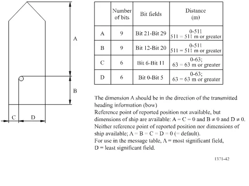
Reference point for reported position and overall dimensions of ship
Position Data
Column Name | Description | Example |
imoNo | IMO Registration Number | 9790139 |
mmsi | Maritime Mobile Service Identity: vessel unique identification number | 636017754 |
deviceType | Equipment Type | AIS |
callsSign | Call Sign | D5MO4 |
shipName | Ship Name | OCEAN BLUE WHALE |
aisShipType | 68 | |
aisDimA | 97 | |
aisDimB | 86 | |
aisDimC | 23 | |
aisDimD | 2 | |
aisEta | Estimated time of arrival; MMDDHHMM UTC
Bits 19-16: month; 1-12; 0 = not available = default
Bits 15-11: day; 1-31; 0 = not available = default
Bits 10-6: hour; 0-23; 24 = not available = default
Bits 5-0: minute; 0-59; 60 = not available = default
For SAR aircraft, the use of this field may be decided by the responsible administration | 12261000 |
aisDestination | Destination | YT<<=>>P'TK |
staticDateTime | Time of Receiving Static Information | 2022-12-26T02:08:06Z |
timestamp | Position Information Reception Time | 2022-12-26T05:52:02Z |
aisClass | AIS Class | A |
nvgStatus | Navigation Status | 0 |
rateOfTurn | Rate of Turn | -128 |
speedOverGround | Vessel Speed | 20 |
positionAccuracy | Position Accuracy | 1 |
longitude | Longitude | 124.65333333 |
latitude | Latitude | 37.21666667 |
courseOverGround | Course Over Ground (COG) | 102 |
trueHeading | Heading | 511 |
elapsed | Delay | 0 |
utcSecond | UTC Seconds | 60 |
dte | Data terminal equipment (DTE) ready (0 = available, 1 = not available = default) | 0 |
specialManeuverIndicator | Data terminal equipment (DTE) ready (0 = available, 1 = not available = default) | 0 |
raimFlag | Data terminal equipment (DTE) ready (0 = available, 1 = not available = default) | 0 |
staticMessageNo | 정적 메시지 번호 | 5 |
locationMessageNo | 위치 메시지 번호 | 27 |
aisMaxDraught | In 1/10 m, 255 = draught 25.5 m or greater, 0 = not available = default; in accordance with IMO Resolution A.851 | 6.8 |
Type of ship
Identifier No. | Special craft |
50 | Pilot vessel |
51 | Search and rescue vessels |
52 | Tugs |
53 | Port tenders |
54 | Vessels with anti-pollution facilities or equipment |
55 | Law enforcement vessels |
56 | Spare - for assignments to local vessels |
57 | Spare - for assignments to local vessels |
58 | Medical transports (as defined in the 1949 Geneva Conventions and Additional Protocols) |
59 | Ships and aircraft of States not parties to an armed conflict |
