



Retrieves vessel information and AIS data for vessels located within a predefined area based on customer requirements. Data is updated approximately every 15 minutes based on AIS data. The API is subject to a rate limit of one request per user every 15 minutes.

Authentication
The Ship API uses Basic Authorization on Swagger UI.
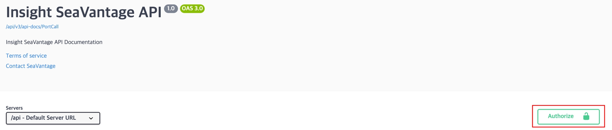
Authentication Steps
1.
Click the [Authorize] button in the top right corner.
2.
Enter the provided username and password in the pop-up window.
3.
Click [Authorize] again to proceed with authentication.
4.
After successful login, click [Close] to close the window.
All API requests from Swagger UI will automatically include the authorization token.
Request Information
Request URL
Request URL : [GET] https://insight.seavantage.com/api/ship/position/area
Execution Steps
1.
2.
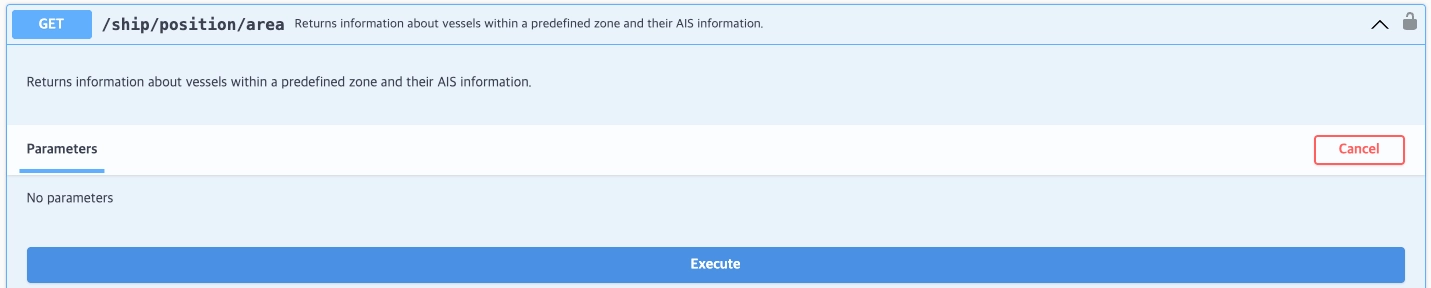
Navigate to the/ship/position/area endpoint.
3.
Click [Try it out] to activate input fields.
4.
Click [Execute].
5.
View results in the response section.
Response Information
The response is returned in the following format, regardless of whether the request is successful or failed.
Sample Response Format
{
"code": 200,
"message": "success",
"error": false,
"timestamp": "2026-04-03T01:47:31.111650473",
"response": [
{
"info": {
"shipId": "001eeb90-6836-4f2e-8ae9-8bdb990d79e8",
"imoNo": "9434163",
"mmsi": "305817000",
"callSign": "V2ID5",
"shipName": "PERNILLE",
"shipType": "CARGO",
"shipTypeBySize": "CARGO03",
"nationCode": "AG",
"built": 2009,
"dwt": 3450
},
"position": {
"imoNo": "9434163",
"mmsi": "305817000",
"deviceType": "AIS",
"callSign": "V2ID5",
"shipName": "PERNILLE",
"aisShipType": 79,
"aisDimA": 74,
"aisDimB": 8,
"aisDimC": 6,
"aisDimD": 6,
"aisEta": "04100600",
"aisDestination": "SEKOG",
"staticDateTime": "2026-04-03T00:49:20Z",
"timestamp": "2026-04-03T01:24:12Z",
"aisClass": "A",
"nvgStatus": 0,
"rateOfTurn": -127,
"speedOverGround": 8.5,
"positionAccuracy": 1,
"longitude": -9.95615167,
"latitude": 39.29651167,
"courseOverGround": 358.8999938964844,
"trueHeading": 359,
"elapsed": 0,
"utcSecond": 11,
"dte": 0,
"specialManeuverIndicator": "0",
"raimFlag": "1",
"staticMessageNo": 5,
"locationMessageNo": 3,
"aisMaxDraught": 54
}
}
]
}
JavaScript
복사
Response Field Descriptions
Top-Level Response Fields
Field | Example Value | Description |
code | 200 | Response status code (used in the same way as standard HTTP status codes).
See the list of codes below for reference. |
message | success | Response message (description based on status) |
error | false | Error flag
true: error occurred
false: successful processing |
timestamp | 2025-05-15T10:56:59.034880881 | Time of response creation (UTC) |
response | Array or Empty Array | Returns an array if data exists; returns an empty array if no data exists |
Response Codes
Code | Description |
200 | Success |
400 | Bad request |
401 | Unauthorized |
403 | Forbidden |
422 | Unprocessable entity |
429 | Too many requests, standard rate limit of 100 requests per minute exceeded |
Detailed Response Description
Depth 1 Field Description (info object)
Field | Example Value | Description | Data Type |
shipId | 001eeb90-6836-4f2e-8ae9-8bdb990d79e8 | SeaVantage internal unique ship ID | varchar(36) - UUID |
imoNo | 9434163 | Ship’s 7-digit International Maritime Organization (IMO) registration number | varchar(10) |
mmsi | 305817000 | Ship’s 9-digit Maritime Mobile Service Identity (MMSI) registration number | varchar(10) |
callSign | V2ID5 | Ship's designated international call sign, used in maritime radio communications. | varchar(7) |
shipName | PERNILLE | Official registered name of the vessel | varchar(100) |
shipType | CARGO | varchar(36) | |
shipTypeBySize | CARGO03 | varchar(36) | |
nationCode | AG | Info
> Vessel identification, classification and registry details
> Capacity and performance characteristics
> Physical dimensions and design details
> Voyage planning details such as PTA, PTB, and destination port information
Position
> Vessel identification and AIS classification details
> Live AIS-based vessel position of vessel
> Navigation and movement status, including speed, course, and heading
> AIS-reported destination and ETA
> Vessel dimension and draft indicators
Updated every 15 minutes | varchar(3) |
built | 2009 | Info
> Vessel identification, classification and registry details
> Capacity and performance characteristics
> Physical dimensions and design details
> Voyage planning details such as PTA, PTB, and destination port information
Position
> Vessel identification and AIS classification details
> Live AIS-based vessel position of vessel
> Navigation and movement status, including speed, course, and heading
> AIS-reported destination and ETA
> Vessel dimension and draft indicators
Updated every 15 minutes | smallint |
dwt | 3450 | Info
> Vessel identification, classification and registry details
> Capacity and performance characteristics
> Physical dimensions and design details
> Voyage planning details such as PTA, PTB, and destination port information
Position
> Vessel identification and AIS classification details
> Live AIS-based vessel position of vessel
> Navigation and movement status, including speed, course, and heading
> AIS-reported destination and ETA
> Vessel dimension and draft indicators
Updated every 15 minutes | integer |
Depth 2 Field Description (position object)
Field | Example Value | Description | Data Type |
imoNo | 9434163 | Ship’s 7-digit International Maritime Organization (IMO) registration number | varchar(10) |
mmsi | 305817000 | Ship’s 9-digit Maritime Mobile Service Identity (MMSI) registration number | varchar(10) |
deviceType | AIS | AIS Equipment Type | varchar(36) |
callSign | V2ID5 | Ship's designated international call sign, used in maritime radio communications. | varchar(7) |
shipName | PERNILLE | Official registered name of the vessel | varchar(36) |
aisShipType | 79 | Vessel type classification code transmitted via the Automatic Identification System (AIS)
(See separate AIS Ship Type table below) | smallint |
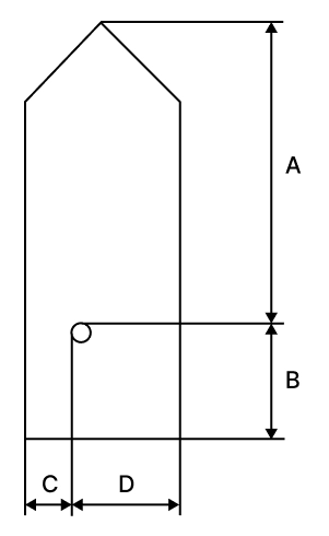
aisDimA | 74 | - Distance from GPS antenna to bow
- Direction: Forward (Bow)
(See AIS dimension image below) | smallint |
aisDimB | 8 | - Distance from GPS antenna to stern
- Direction: Backward (Stern)
(See AIS dimension image below) | smallint |
aisDimC | 6 | - Distance from GPS antenna to port side
- Direction: Left (Port)
(See AIS dimension image below) | smallint |
aisDimD | 6 | - Distance from GPS antenna to starboard side
- Direction: Right (Starboard)
(See AIS dimension image below) | smallint |
aisEta | 04100600 | AIS Estimated Time of Arrival (ETA) | varchar(8) |
aisDestination | SEKOG | AIS Destination | varchar(32) |
staticDateTime | 2026-04-03T00:49:20Z | Static Information Reception Time: Refers to the time when static information about the vessel was last updated. | timestamp |
timestamp | 2026-04-03T01:24:12Z | Position Information Reception Time: Represents the time when the AIS data was received. | timestamp |
aisClass | A | Class of AIS device:
Class A (commercial)
Class B (smaller vessels) | char |
nvgStatus | 0 | Navigational Status
(See Navigational Status table below) | smallint |
rateOfTurn | -127 | Rate at which the vessel is turning, typically in degrees/min. | real |
speedOverGround | 8.5 | Current vessel speed relative to the Earth’s surface (in knots). | real |
positionAccuracy | 1 | Indicator of GPS precision
1 = high (<= 10 m)
0 = low (> 10 m) = default | smallint |
longitude | -9.95615167 | Vessel’s latest known position coordinate: longitude | numeric(12, 8) |
latitude | 39.29651167 | Vessel’s latest known position coordinates: latitude | numeric(12, 8) |
courseOverGround | 358.8999938964844 | Direction of the vessel’s movement (degrees) | real |
trueHeading | 359 | Vessel’s actual heading direction | smallint |
elapsed | 0 | Time delay (in minutes) since the last position update | integer |
utcSecond | 11 | UTC Second | smallint |
dte | 0 | Data terminal equipment (DTE) ready
0 = available
1 = not available = default | smallint |
specialManeuverIndicator | 0 | 0 = not available = default
1 = not engaged in special maneuver
2 = engaged in special maneuver (i.e.: regional passing arrangement on Inland Waterway) | char |
raimFlag | 1 | Receiver autonomous integrity monitoring (RAIM) flag of electronic position fixing device
0 = RAIM not in use = default
1 = RAIM in use | char |
staticMessageNo | 5 | Static Message Number | smallint |
locationMessageNo | 3 | Location Message Number | smallint |
aisMaxDraught | 54 | Maximum Draught | real |
Appendix
Ship Type by Size Classification
Bulk Carrier
Classification Code | Classification | Lower Range (DWT) | Higher Range (DWT) |
BULK 05 | Handysize | 0 | 34,999 |
BULK 04 | Handymax | 35,000 | 59,999 |
BULK 03 | Panamax | 60,000 | 79,999 |
BULK 02 | Capesize | 80,000 | 179,999 |
BULK 01 | VLBC | 180,000 |
Cargo
Classification Code | Classification | Lower Range (DWT) | Higher Range (DWT) |
CARGO 04 | General Cargo | 0 | 2,999 |
CARGO 03 | General Cargo | 3,000 | 7,499 |
CARGO 02 | General Cargo | 7,500 | 37,999 |
CARGO 01 | General Cargo | 38,000 |
Chemical Tanker
Classification | Vessel Type | Classification |
CHEMICAL_TANKER01 | Chemical Tanker | Chemical tanker, combined chemical and oil tanker |
Container
Classification Code | Classification | Lower Range (TEU) | Higher Range (TEU) |
CONTAINER 07 | Small Feeder | 0 | 1,000 |
CONTAINER 06 | Feeder Containership | 1,001 | 2,000 |
CONTAINER 05 | Feedermax Containership | 2,001 | 3,000 |
CONTAINER 04 | Panamax Containership | 3,001 | 5,100 |
CONTAINER 03 | Post-Panamax Containership | 5,101 | 10,000 |
CONTAINER 02 | Neo-Panamax Containership | 10,001 | 14,500 |
CONTAINER 01 | ULCV Containership | 14,501 |
LNG
Classification Code | Classification | Lower Range (Gross Tonnes) | Higher Range (Gross Tonnes) |
LNG 03 | LNG Gas Carrier | 0 | 73,000 |
LNG 02 | LNG Gas Carrier | 73,001 | 147,000 |
LNG 01 | LNG Gas Carrier | 147,001 |
LPG
Classification Code | Classification | Lower Range (Gross Tonnes) | Higher Range (Gross Tonnes) |
LPG 03 | LPG Gas Carrier | 0 | 4,500 |
LPG 02 | LPG Gas Carrier | 4,501 | 26,000 |
LPG 01 | LPG Gas Carrier | 26,001 |
Pure Car Carrier (PCC)
Classification Code | Classification | Lower Range (Gross Tonnes) | Higher Range (Gross Tonnes) |
PCC 03 | PCC/PCTC | 0 | 35,000 |
PCC 02 | PCC/PCTC | 35,001 | 61,000 |
PCC 01 | PCC/PCTC | 61,001 |
Ro-ro
Classification Code | Classification | Lower Range (Gross Tonnes) | Higher Range (Gross Tonnes) |
RORO 03 | Ro-ro Cargo | 0 | 0 |
RORO 02 | Ro-ro Cargo | 8,501 | 48,000 |
RORO 01 | Ro-ro Cargo | 48,001 |
Tanker
Classification Code | Vessel Type | Classification |
TANKER 05 | Crude Oil Tanker | Tanker- Panamax |
TANKER 04 | Crude Oil Tanker | Tanker- Aframax |
TANKER 03 | Crude Oil Tanker | Tanker- Suezmax |
TANKER 02 | Crude Oil Tanker | Tanker- VLCC |
TANKER 01 | Crude Oil Tanker | Tanker- ULCC |
Product Tanker
Classification | Vessel Type |
PRODUCT_TANKER01 | Product Tanker |
Tug
Classification | Vessel Type |
TUG01 | Tug |
FPSO
Classification | Vessel Type | Classification |
FPSO01 | FPSO | Floating drilling production tanker,
floating gas production,
floating gas storage,
floating LNG production and storage FLNG,
floating power station,
floating production tanker,
floating storage tanker |
ETC
Classification | Vessel Type |
ETC01 | ETC All |
AIS Ship Type
Type Code | Description | Type Code | Description |
0 | Not available (default) | 58 | Medical Transport |
1–19 | Reserved for future use | 59 | Noncombatant ship according to RR Resolution No. 18 |
20 | Wing in ground (WIG), all ships of this type | 60 | Passenger, all ships of this type |
21 | Wing in ground (WIG), Hazardous category A | 61 | Passenger, Hazardous category A |
22 | Wing in ground (WIG), Hazardous category B | 62 | Passenger, Hazardous category B |
23 | Wing in ground (WIG), Hazardous category C | 63 | Passenger, Hazardous category C |
24 | Wing in ground (WIG), Hazardous category D | 64 | Passenger, Hazardous category D |
25–29 | Wing in ground (WIG), Reserved for future use | 65–68 | Passenger, Reserved for future use |
30 | Fishing | 69 | Passenger, No additional information |
31 | Towing | 70 | Cargo, all ships of this type |
32 | Towing: length exceeds 200m or breadth exceeds 25m | 71 | Cargo, Hazardous category A |
33 | Dredging or underwater ops | 72 | Cargo, Hazardous category B |
34 | Diving ops | 73 | Cargo, Hazardous category C |
35 | Military ops | 74 | Cargo, Hazardous category D |
36 | Sailing | 75–78 | Cargo, Reserved for future use |
37 | Pleasure Craft | 79 | Cargo, No additional information |
38–39 | Reserved | 80 | Tanker, all ships of this type |
40 | High speed craft (HSC), all ships of this type | 81 | Tanker, Hazardous category A |
41 | High speed craft (HSC), Hazardous category A | 82 | Tanker, Hazardous category B |
42 | High speed craft (HSC), Hazardous category B | 83 | Tanker, Hazardous category C |
43 | High speed craft (HSC), Hazardous category C | 84 | Tanker, Hazardous category D |
44 | High speed craft (HSC), Hazardous category D | 85–88 | Tanker, Reserved for future use |
45–48 | High speed craft (HSC), Reserved for future use | 89 | Tanker, No additional information |
49 | High speed craft (HSC), No additional information | 90 | Other Type, all ships of this type |
50 | Pilot Vessel | 91 | Other Type, Hazardous category A |
51 | Search and Rescue vessel | 92 | Other Type, Hazardous category B |
52 | Tug | 93 | Other Type, Hazardous category C |
53 | Port Tender | 94 | Other Type, Hazardous category D |
54 | Anti-pollution equipment | 95–98 | Other Type, Reserved for future use |
55 | Law Enforcement | 99 | Other Type, no additional information |
56–57 | Spare - Local Vessel |
AIS Dimension
Number of bits | Bit fields | Distance (m) | |
A | 9 | Bit 21 - Bit 29 | 0 - 511:
511 = 511m or greater |
B | 9 | Bit 12 - Bit 20 | 0 - 511:
511 = 511m or greater |
C | 6 | Bit 6 - Bit 11 | 0 - 63:
63 = 63m or greater |
D | 6 | Bit 0 - Bit 5 | 0 - 63:
63 = 63m or greater |
The A value should be entered on the vessel’s heading direction (bow).
•
When the reference point of the reported position is unavailable, but dimension information is provided:
◦
A = C = 0, and B ≠ 0, D ≠ 0
•
When both the reference point and dimension information are unavailable:
◦
A = B = C = D = 0 (default)
•
In the message table:
◦
A is the most significant field, D is the least significant field
AIS Navigation Status
Code | Status | Description |
0 | Under way using engine | The vessel is actively moving through the water under engine power. |
1 | At anchor | The vessel is anchored and stationary. |
2 | Not under command | The vessel is unable to maneuver due to exceptional circumstances, such as engine failure or loss of steering. Other vessels should navigate with caution. |
3 | Restricted maneuverability | The vessel's ability to maneuver is limited due to operations or environmental conditions. Other vessels should keep clear. |
4 | Constrained by her draught | The vessel is restricted in its ability to deviate from its course due to its deep draught relative to water depth. |
5 | Moored | The vessel is secured by mooring lines, typically tied to a dock or port facility. |
6 | Aground | The vessel has run aground and is stuck in shallow water. It is immobile until freed. |
7 | Engaged in fishing | The vessel is currently engaged in fishing operations. Navigating vessels should allow space, as nets or lines may be deployed. |
8 | Under way sailing | Indicates that the vessel is currently sailing. This may include movement using sails instead of engine power. |
9 | Reserved for future amendment of navigational status | This value is reserved for future use to represent a specific navigation status not yet defined. |
10 | Reserved for future amendment of navigational status | This value is reserved for future use to represent a specific navigation status not yet defined. |
11 | Power-driven vessel towing astern (regional use) | The vessel is towing another vessel behind it. Most commonly used by tugboats. |
12 | Power-driven vessel pushing ahead or towing alongside (regional use) | The vessel is pushing another vessel ahead or towing it alongside. Common in inland waterway operations. |
13 | Reserved for future use | Reserved by standard bodies for future status codes. |
14 | AIS-SART (active), MOB-AIS, EPIRB-AIS | Distress-related AIS devices are active: AIS-SART (Search and Rescue Transponder), MOB-AIS (Man Overboard), or EPIRB-AIS (Emergency Beacon). Immediate attention may be required. |
15 | Undefined = default (also used by AIS-SART, MOB-AIS and EPIRB-AIS under test) | Represents the default status when the vessel’s navigation state is not explicitly defined. |