

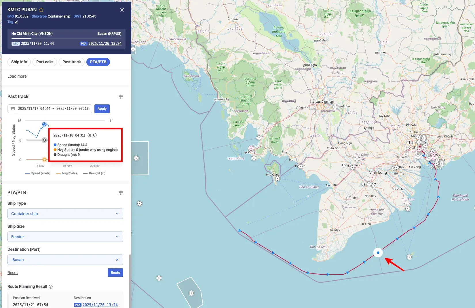
Past Track visualizes a vessel’s historical route on the map, along with time-based changes in Speed, Navigation Status, and Draught.
Past Track
•
Select the desired date range using the date selector.
•
After choosing the period, click Apply to display the vessel’s past track for the selected range.
◦
Speed, navigation status, and draught are shown as time-series charts:
▪
Speed (blue line): Vessel speed over time
▪
Nvg Status (orange line): Vessel navigation status
▪
Draught (gray line): Vessel draught over time
◦
The vessel’s historical sailing route is also displayed on the map.
◦
The gray shaded area displayed on the chart represents the period during which the vessel was berthed at the port.

•
When you hover over the chart, you can view the Speed, Navigation Status, and Draught values for that specific timestamp, and the vessel’s position at that moment is simultaneously shown on the map.
•
When you drag to select a specific range on the chart, the chart and the vessel’s historical track on the map are updated to reflect the selected time period.
•
Click Reset zoom to clear the selection and return to the default time range.

Note
The AIS timestamps displayed on the chart and map are shown based on the Timezone setting in your profile.
Options
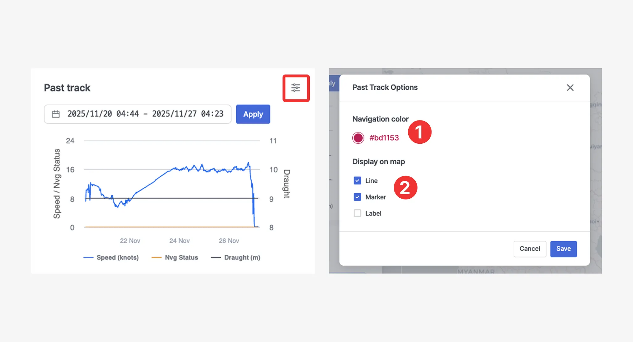
No. | Item | Description |
1 | Navigation color | Sets the color of the track line. |
2 | Display on map | • Line: Displays the vessel track line on the map.
• Marker: Displays markers along the vessel track on the map.
• Label: Displays the received timestamp on the track markers. |
AIS Navigation Status Description
Code | Status | Description |
0 | Under way using engine | The vessel is actively moving through the water under engine power. |
1 | At anchor | The vessel is anchored and stationary. |
2 | Not under command | The vessel is unable to maneuver due to exceptional circumstances, such as engine failure or loss of steering. Other vessels should navigate with caution. |
3 | Restricted maneuverability | The vessel's ability to maneuver is limited due to operations or environmental conditions. Other vessels should keep clear. |
4 | Constrained by her draught | The vessel is restricted in its ability to deviate from its course due to its deep draught relative to water depth. |
5 | Moored | The vessel is secured by mooring lines, typically tied to a dock or port facility. |
6 | Aground | The vessel has run aground and is stuck in shallow water. It is immobile until freed. |
7 | Engaged in fishing | The vessel is currently engaged in fishing operations. Navigating vessels should allow space, as nets or lines may be deployed. |
8 | Under way sailing | Indicates that the vessel is currently sailing. This may include movement using sails instead of engine power. |
9 | Reserved for future amendment of navigational status | This value is reserved for future use to represent a specific navigation status not yet defined. |
10 | Reserved for future amendment of navigational status | This value is reserved for future use to represent a specific navigation status not yet defined. |
11 | Power-driven vessel towing astern (regional use) | The vessel is towing another vessel behind it. Most commonly used by tugboats. |
12 | Power-driven vessel pushing ahead or towing alongside (regional use) | The vessel is pushing another vessel ahead or towing it alongside. Common in inland waterway operations. |
13 | Reserved for future use | Reserved by standard bodies for future status codes. |
14 | AIS-SART (active), MOB-AIS, EPIRB-AIS | Distress-related AIS devices are active: AIS-SART (Search and Rescue Transponder), MOB-AIS (Man Overboard), or EPIRB-AIS (Emergency Beacon). Immediate attention may be required. |
15 | Undefined = default (also used by AIS-SART, MOB-AIS and EPIRB-AIS under test) | Represents the default status when the vessel’s navigation state is not explicitly defined. |