

This feature provides a screen where you can view a vessel’s basic specifications (Ship Info) and its real-time operating status (AIS Info).
Information Overview
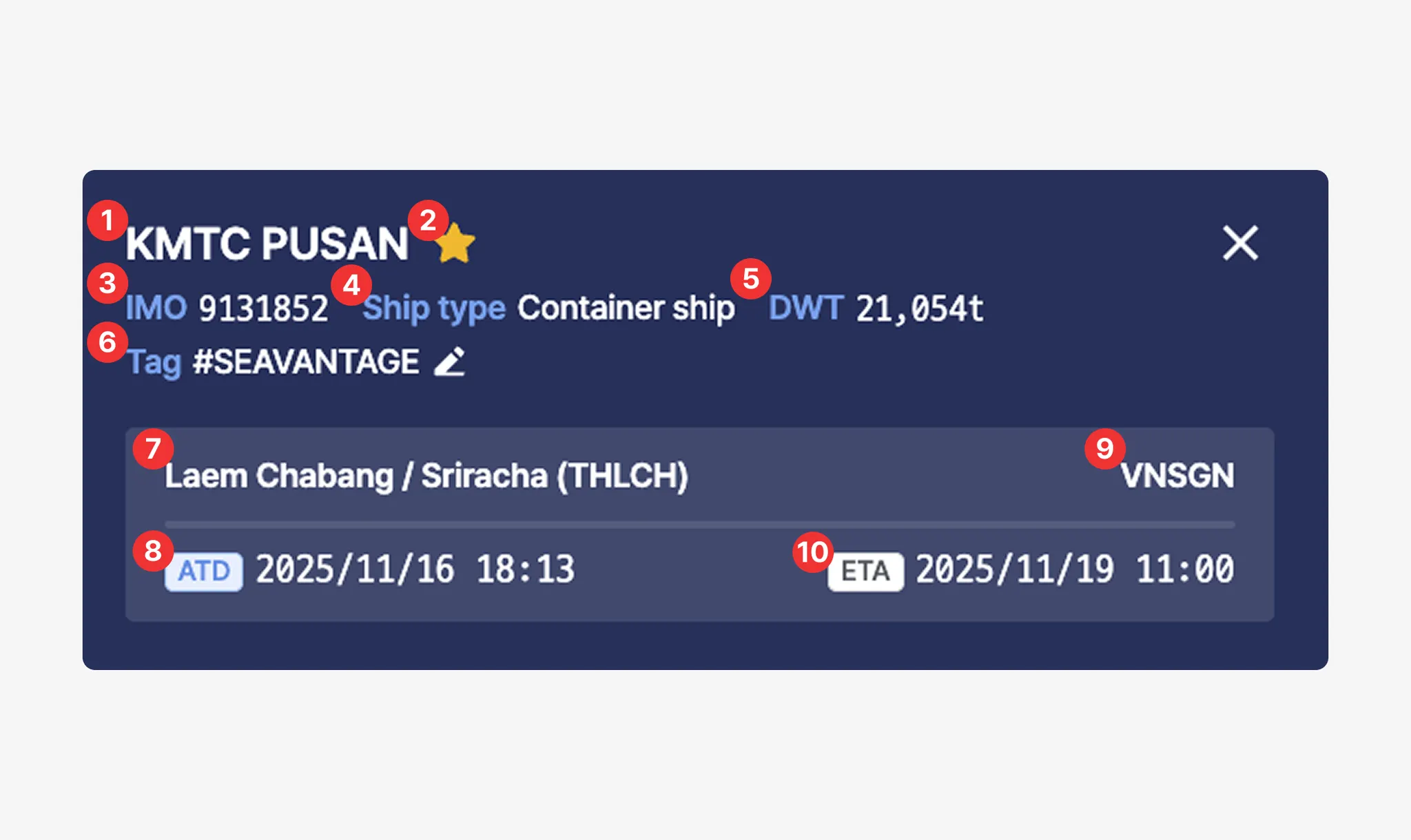
No. | Description | Example |
1 | Vessel Name | KMTC PUSAN |
2 | Favorite (Click the star icon to add or remove from favorites.) | |
3 | Vessel IMO Registration Number | 9131852 |
4 | Vessel Type | Container ship |
5 | Deadweight Tonnage (DWT) | 21,054t |
6 | Tags | SEAVANTAGE |
7 | Most recent port name / UN/LOCODE based on SeaVantage Port Call data | Gwangyang (KRKAN) |
8 | ATD (Actual Time of Departure for the most recent port, based on SeaVantage Port Call data, in local time) | 2025/11/04 17:28 |
9 | Destination port predicted based on AIS Destination information | Ho Chi Minh City (VNSGN) |
10 | PTA (Predicted Time of Arrival / Berthing at the predicted destination port) | 2025/11/10 03:11 |
•
When you hover your cursor over the timestamp, you can view the PTB, PTA, and ETA information.
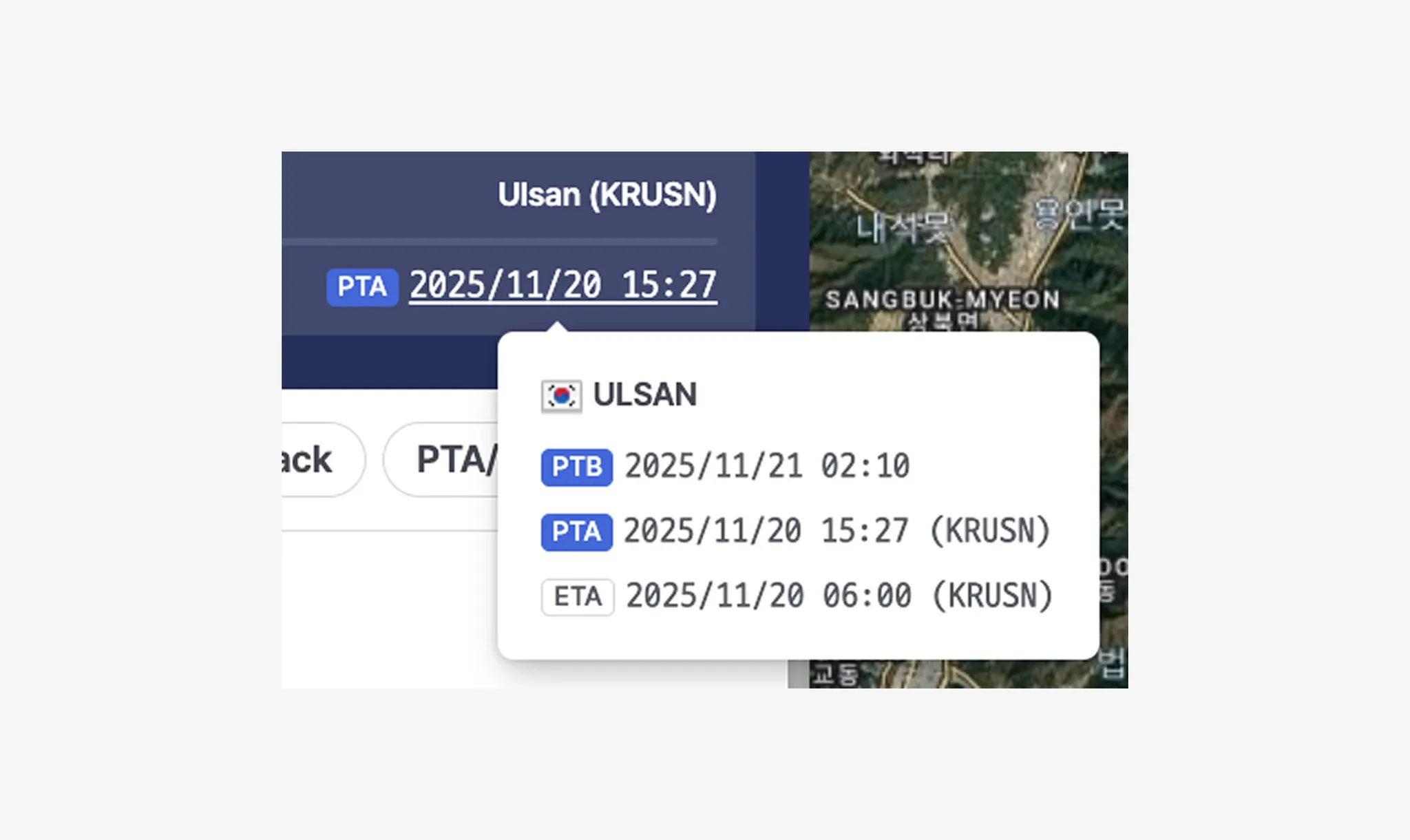
Item | Description |
PTB | Predicted Time of Berthing (Local Time), calculated using MTN + Port Congestion data.
*MTN : A maritime traffic network generated from years of accumulated AIS data and advanced analysis. |
PTA | Predicted Time of Arrival at the estimated destination port (Local Time) |
ETA | Estimated Time of Arrival collected from AIS data (UTC) |
Ship Info
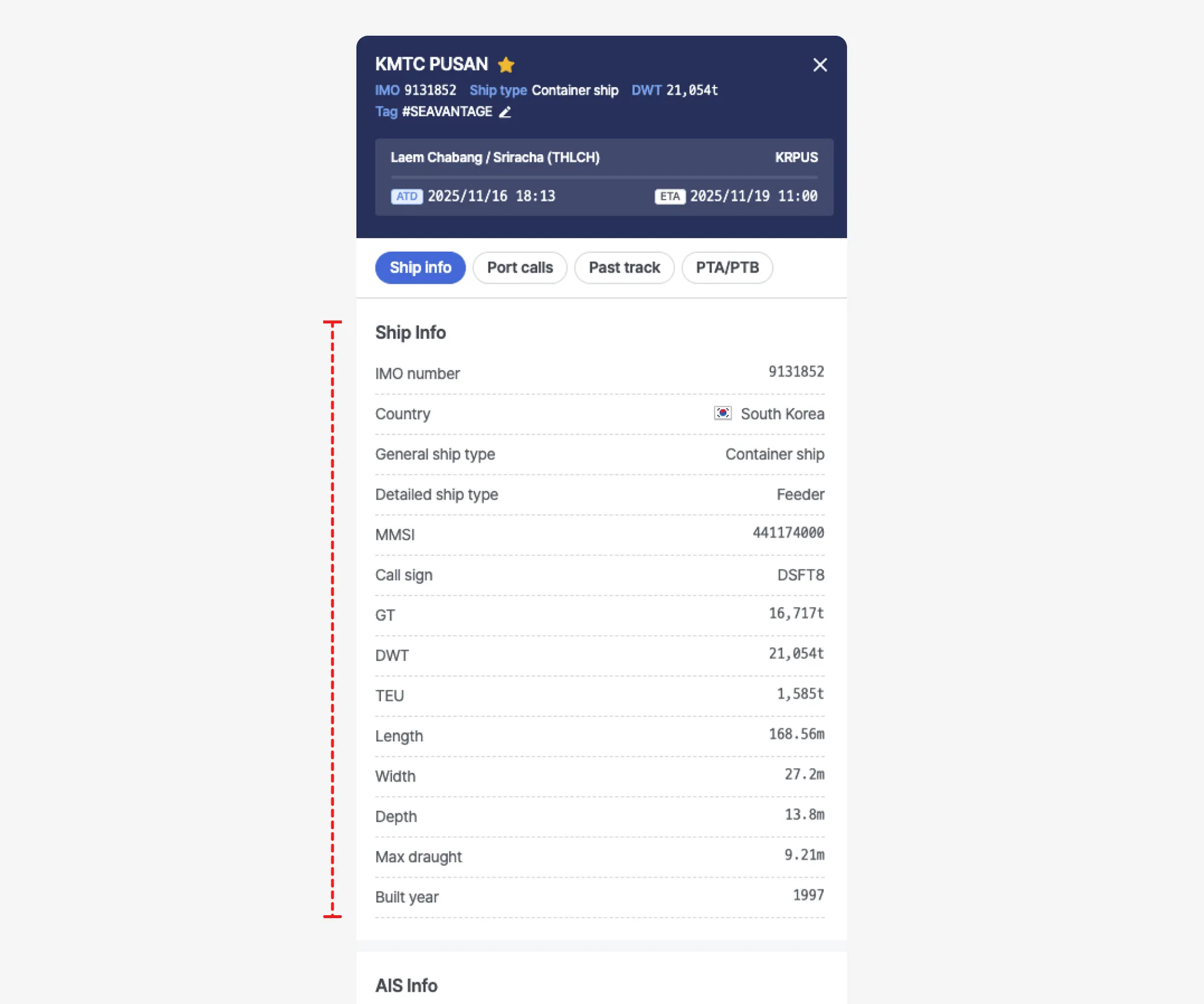
Item | Description |
IMO number | Vessel’s International Maritime Organization (IMO) registration number |
Country | Flag State (Country of Registration) |
General ship type | |
Detailed ship type | |
MMSI | Vessel’s Maritime Mobile Service Identity (MMSI) registration number |
Call sign | Vessel's designated international call sign |
GT | Gross tonnage (GT) |
DWT | Deadweight tonnage (DWT) |
TEU | TEU capacity |
Length | Overall length |
Width | Overall width |
Depth | Overall depth |
Max draught | Maximum draught |
Built year | Year built |
AIS Info
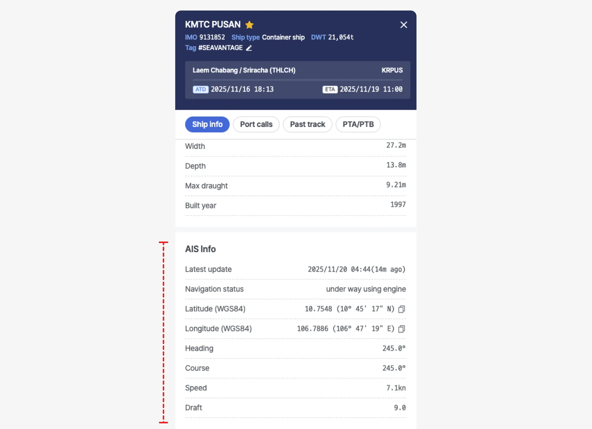
Item | Description |
Latest update | Time of position received (UTC) |
Navigation status | Navigation status
(See Navigational Status table below) |
Latitude (WGS84) | Latitude (coordinate) |
Longitude (WGS84) | Longitude (coordinate) |
Heading | Vessel’s actual heading direction |
Course | Direction of the vessel’s movement (degrees) |
Speed | Current vessel speed relative to the Earth’s surface (in knots). |
Draft | Maximum draught |
Appendix
Ship Type by Size Classification
Bulk Carrier
Classification Code | Classification | Lower Range (DWT) | Higher Range (DWT) |
BULK 05 | Handysize | 0 | 34,999 |
BULK 04 | Handymax | 35,000 | 59,999 |
BULK 03 | Panamax | 60,000 | 79,999 |
BULK 02 | Capesize | 80,000 | 179,999 |
BULK 01 | VLBC | 180,000 |
Cargo
Classification Code | Classification | Lower Range (DWT) | Higher Range (DWT) |
CARGO 04 | General Cargo | 0 | 2,999 |
CARGO 03 | General Cargo | 3,000 | 7,499 |
CARGO 02 | General Cargo | 7,500 | 37,999 |
CARGO 01 | General Cargo | 38,000 |
Chemical Tanker
Classification | Vessel Type | Classification |
CHEMICAL_TANKER01 | Product Tanker | Chemical tanker, combined chemical and oil tanker |
Container
Classification Code | Classification | Lower Range (TEU) | Higher Range (TEU) |
CONTAINER 07 | Small Feeder | 0 | 1,000 |
CONTAINER 06 | Feeder Containership | 1,001 | 2,000 |
CONTAINER 05 | Feedermax Containership | 2,001 | 3,000 |
CONTAINER 04 | Panamax Containership | 3,001 | 5,100 |
CONTAINER 03 | Post-Panamax Containership | 5,101 | 10,000 |
CONTAINER 02 | Neo-Panamax Containership | 10,001 | 14,500 |
CONTAINER 01 | ULCV Containership | 14,501 |
LNG
Classification Code | Classification | Lower Range (Gross Tonnes) | Higher Range (Gross Tonnes) |
LNG 03 | LNG Gas Carrier | 0 | 73,000 |
LNG 02 | LNG Gas Carrier | 73,001 | 147,000 |
LNG 01 | LNG Gas Carrier | 147,001 |
LPG
Classification Code | Classification | Lower Range (Gross Tonnes) | Higher Range (Gross Tonnes) |
LPG 03 | LPG Gas Carrier | 0 | 4,500 |
LPG 02 | LPG Gas Carrier | 4,501 | 26,000 |
LPG 01 | LPG Gas Carrier | 26,001 |
Pure Car Carrier (PCC)
Classification Code | Classification | Lower Range (Gross Tonnes) | Higher Range (Gross Tonnes) |
PCC 03 | PCC/PCTC | 0 | 35,000 |
PCC 02 | PCC/PCTC | 35,001 | 61,000 |
PCC 01 | PCC/PCTC | 61,001 |
Ro-ro
Classification Code | Classification | Lower Range (Gross Tonnes) | Higher Range (Gross Tonnes) |
RORO 03 | Ro-ro Cargo | 0 | 0 |
RORO 02 | Ro-ro Cargo | 8,501 | 48,000 |
RORO 01 | Ro-ro Cargo | 48,001 |
Tanker
Classification Code | Vessel Type | Classification |
TANKER 05 | Crude Oil Tanker | Tanker- Panamax |
TANKER 04 | Crude Oil Tanker | Tanker- Aframax |
TANKER 03 | Crude Oil Tanker | Tanker- Suezmax |
TANKER 02 | Crude Oil Tanker | Tanker- VLCC |
TANKER 01 | Crude Oil Tanker | Tanker- ULCC |
Product Tanker
Classification | Vessel Type |
PRODUCT_TANKER01 | Product Tanker |
Tug
Classification | Vessel Type |
TUG01 | Tug |
FPSO
Classification | Vessel Type | Classification |
FPSO01 | FPSO | Floating drilling production tanker,
floating gas production,
floating gas storage,
floating LNG production and storage FLNG,
floating power station,
floating production tanker,
floating storage tanker |
ETC
Classification | Vessel Type |
ETC01 | ETC All |
AIS Navigation Status Description
Code | Status | Description |
0 | Under way using engine | The vessel is actively moving through the water under engine power. |
1 | At anchor | The vessel is anchored and stationary. |
2 | Not under command | The vessel is unable to maneuver due to exceptional circumstances, such as engine failure or loss of steering. Other vessels should navigate with caution. |
3 | Restricted maneuverability | The vessel's ability to maneuver is limited due to operations or environmental conditions. Other vessels should keep clear. |
4 | Constrained by her draught | The vessel is restricted in its ability to deviate from its course due to its deep draught relative to water depth. |
5 | Moored | The vessel is secured by mooring lines, typically tied to a dock or port facility. |
6 | Aground | The vessel has run aground and is stuck in shallow water. It is immobile until freed. |
7 | Engaged in fishing | The vessel is currently engaged in fishing operations. Navigating vessels should allow space, as nets or lines may be deployed. |
8 | Under way sailing | Indicates that the vessel is currently sailing. This may include movement using sails instead of engine power. |
9 | Reserved for future amendment of navigational status | This value is reserved for future use to represent a specific navigation status not yet defined. |
10 | Reserved for future amendment of navigational status | This value is reserved for future use to represent a specific navigation status not yet defined. |
11 | Power-driven vessel towing astern (regional use) | The vessel is towing another vessel behind it. Most commonly used by tugboats. |
12 | Power-driven vessel pushing ahead or towing alongside (regional use) | The vessel is pushing another vessel ahead or towing it alongside. Common in inland waterway operations. |
13 | Reserved for future use | Reserved by standard bodies for future status codes. |
14 | AIS-SART (active), MOB-AIS, EPIRB-AIS | Distress-related AIS devices are active: AIS-SART (Search and Rescue Transponder), MOB-AIS (Man Overboard), or EPIRB-AIS (Emergency Beacon). Immediate attention may be required. |
15 | Undefined = default (also used by AIS-SART, MOB-AIS and EPIRB-AIS under test) | Represents the default status when the vessel’s navigation state is not explicitly defined. |